Saturday, September 26, 2009

Fall on the Lower Rogue River

About a Mile up the Rogue River Trail.

Today I satisfied some long-standing curiosity and drove up the Rogue River from Gold Beach to Agness and the Rogue River Trail. I had no particular destination, just the desire to see what was there to see. The drive upriver to Agness is about 33 miles and after the first 5 or 6 miles you're into beautiful country, with wonderful mountain views and an occasional good river view. There were not a lot of places to pull over and really see the river, but there were enough. A couple of bridge crossings really took my breath away. From Agness one has to backtrack a few miles to reach the intersection that goes to the trail. That road is odd -- one lane with turnouts on every curve as it follows the river. Signage is great, so no fears of being lost.

The day was surprisingly hot and sunny and while I only walked about a mile along the Rogue River Trail, I was disappointed that the river was not visible for most of that time. The trail was lovely however, and if I'd had the gumption to go further I'm sure I would have seen much more of the river. I opted to walk the section of the trail that travels east, through the Wild & Scenic designated area. I think it's about 15 miles, with inns along the way, or camping. There is another trail that follows the river west from Agness. I want to do that one someday, too. The salmon fishermen were out in hordes, from Gold Beach to the last place I walked.

I think these are wild rosehips, but I would not swear to that. The leaves look like roses. Whatever they are, they were rather spectacular and there were plenty of them.

I loved the way the light was shining through the silk of this seed pod. I was looking for signs of autumn, and these two photos really said autumn to me.

This bridge is about a half mile up the trail, crossing one of many creeks that feed into the Rogue.

This fabulous view is from a bridge about halfway up the road to Agness. I was headed back to Gold Beach at this point, but the light and colors here drew me to a fast stop. There are a couple of fishing boats in this photo, but a little hard to see.

I learned -- or re-learned -- a few truisms today. One, never trust a battery supplied for 'free' with a battery charger. I popped new and fully charged ones into my camera before leaving home, checked to see that it worked, didn't take spares because I never need them. These died after about 2 photos, 10 miles upriver. A lovely lady at the Agness Store saved my bacon. I'd like to have spent more time here -- lots of useful and fun stuff at reasonable prices.

Two, it's always hotter inland than it is on the coast. I have a hard time remembering that one when it comes to driving up the local rivers.

Three, if one is eligible for Medicare and accustomed to a cool coastal climate, one really should not attempt a hike in the hot sun when the temp is hovering in the mid-nineties. Along with that, one should also not make such an attempt when one has been on an 800 calorie diet for a week, even if it's a very healthy 800 calories. My body complained vigorously!

However, all in all it was a lovely exploration and now I know 'what's up there'. I'd like to make another trip, hike around Agness, and also more on the Rogue River Trail. Another day.

Sunday, September 20, 2009

Whalehead Beach to Indian Sands

Whalehead Beach and Whalehead Cape in the distance.

My body and spirit were calling for a good workout this morning. The weather is fabulous -- warm and sunny and perfect. I opted for a hike that's close to home, since I had other things to do today. I'd intended to walk all the way from Whalehead Beach to the Thomas Creek Bridge, which would have been a round trip of a little over 5.5 miles, but once I set out I knew I was too lazy for that one, so I decided to go as far as Indian Sands, a round trip of around 3 miles. Nobody seems to know when the name Whalehead originated, but it has apparently been in use since the pioneer days. Whalehead Island is hollow to seaward and has a hole in the top. At just the right tides, water surges into the cavity and spouts out the top and is said to resemble a whale in those moments.

I never really know what to expect when I head off on the Coast Trail, but I've never been disappointed with what I find. In this instance, the trail led sharply uphill for awhile before reaching a lovely viewpoint, above. There are plenty of long uphill stretches in this first portion of the hike, which William Sullivan says is only a half mile. I'm sure he's correct, but because of all the long up and down stretches, it feels a lot longer! Great to get the body warm and the heart racing, however. At the half mile point the trail reaches and parallels the highway for a short distance, just long enough to bypass a deep, steep chasm. After that, the terrain is comfortable, with gentle ups and downs, passing through a lovely forest and paralleling a small creek for awhile, before reaching Indian Sands.


Views along this section were also lovely. Hidden coves abound along this coast.

This plaque was atop a mass of concrete at the above viewpoint. I love the wording on it. You can click on the photo to enlarge and read, but this is what it says:

Stan the Man
Husband, Dad, Granddad
A
Hard Worker Who
Loved and Cared for
Everyone

6-20-27

Went Flying
5-6-09

I'm guessing this mass of concrete contains his ashes. What a lovely tribute!

Indian Sands is an interesting place. I couldn't find any information regarding the origin of that name, but I'm sure it would be interesting. The Coast Trail skirts the edge of it along the forest, but the sandy bluff is huge and offers expansive views. I hiked around for awhile, following the path of deer and other smaller critters. I gravitated towards this rocky outcropping with the natural bridge on the left. You may need to click on the photo in order to enlarge and see that it really is an opening, not just a small inlet. This bluff is hilly, and walking uphill in loose sand is great for the legs and heart. After satisfying all my curiosity, I headed back to my car. All in all the trip took about two hours -- a perfect start to my day.
Saturday, September 12, 2009

Crater Lake and the Upper Rogue River


I did mention yesterday that the lake was blue, did I not? I found this combination of colors irresistible as the light and shadows played over the early morning stillness. Yes, the fatigue of last night dissipated enough by this morning that we opted to make the hour's drive back up to the lake for just this view, just this wonderful morning light. I'm so glad we did!


This is the Phantom Ship rock once more, cast in the reflection of the still lake. I cannot describe just how beautiful the scene really was, with that incredible reflection all around the entire scene.


More plays of blue and reflections, with Mt. Theissen in the distance. At this point, we turned around and headed back down the mountain, but just these few views from the east side were well worth the drive. Besides, we had other places along the highway we wanted to explore.

This photo is actually from day one -- somehow it looks better to me today than it did late Friday night when I was so tired and bleary-eyed. This big rock with the green lichen or moss is spectacular, in a rather subtle kind of way.


Our next stop -- the same beautiful rapids I stopped to see last night, but in much better light. Today, we walked the length of the path and discovered the Rogue River Gorge. I saw a bit of it last night, but there was so much to learn here! These rapids are just above the falls that feed into the Gorge.


This is the video I shot Friday afternoon, and 'lost'. Sadly, even this cannot show the full scope of this beautiful spot. There was a tree to my left that I could not pan past, thus only the major part of the falls is shown. It's a little dark because of the time of day but better than a still photo, anyway.

Is this not gorgeous? This is beyond the waterfall, where the river flows through this deep, narrow gorge at the rate of 410,000 gallons per minute.


You can click on this photo enlarge, read what it has to say about this section of the river. None of this comes close to describing how it feels to be there, to hear it and see it.


Next, we stopped at the Natural Bridges, where the Rogue disappears into the rock and reappears a bit further, bursting right out of the rock after its underground journey. This photo is from a bridge just below where all this happens.


This is where the river charges out of the rock. Unfortunately, the light didn't allow the camera to pick up on the dark 'hole', but you get the idea. You can see it boiling out of nothing. It helps to click on the photo, enlarge it, so that the dark shadows open up a bit to show the rock.


I think this is just below the 'hole'. Spectacular whitewater!


Another sign to click on, get the real details of this site.


This photo is from way above, showing the lava flow and rocks that cover the 200 feet of hidden river channel. The river reappears just beyond this stretch of rock.


Another interpretive sign that explains it much better than I can!


Our last stop was Mill Creek Falls, although there was supposed to be another waterfall in the area as well, so I'm not sure if this is Mill Creek or the other. Whatever its name, it was spectacular and well worth the walk to find it. Unfortunately, the photo doesn't give much in the way of scale, but this was a huge waterfall barreling off the side of the cliff into the tiny Rogue below. Breathtaking to watch.

Quite a blow to our senses today, temperature wise. From the coolness of high elevations at Crater Lake, to 95 sweltering degrees in the lowlands between Shady Cove and the Smith River (and a passenger who didn't understand my disdain for AC), to a quick 30 degree temperature drop once we hit the western side of the Coastal mountains. In truth, I was a bit astonished at how quickly the temps dropped once we passed through the California inspection station and headed almost imperceptibly downhill. Ten degrees quickly, another 10 fairly quickly, until within 30 minutes we were at 60 really cool degrees. And fog, of course! For once, I was not unhappy to see it. And, while I love the mountains and rivers, it's always good to get back to that lovely ocean with the waves crashing into shore.

Friday, September 11, 2009

Crater Lake

The first thing that hits your senses is the color. There's nothing subtle about it in the least. It reaches right up, smacks you in the face and knocks your socks off. And no matter how long you look at it, that sense of incredulity never seems to waver. This is the quintessential view as you reach the visitor's center from the south entrance. Indescribably, impossibly, blue. It's the deepest lake in the US and the 7th deepest lake in the world, and all that depth does some fancy light refracting to produce this color.

We found it difficult to tear ourselves away from almost every place we stopped. The road around the lake is supposed to be 33 miles, and since it took us about 5 hours to make the circuit you can see we spent more time stopping and gawking and taking photos and playing tourist than we spent driving. By far.


This is also from the visitor's center area, looking to the opposite side of the lake with one of the tour boats that slowly circle the lake. I'm astonished at how many people take this boat, because the only way to get on one is to hike over a mile down a steep trail, and of course, back up. That trail is also the only place where one can actually get to the lakeshore. We did not make the attempt. Old folks. Lazy.


I thought there was some slight chance that I would remember where all these photos were taken, but apparently not. It's been a looooooong day and I'm pooped, brain on serious malfunction.


I'm not in love with most of my photos from this day -- you wouldn't think it would be all that difficult to take fabulous photos of such a fabulous place, would you. Still, the color and reflections are there, always. We really lucked out with the weather -- clear, sunny, wonderfully warm. Didn't quite crack 80, according to the temperature sensor in my car, but it was warm and perfect, a great escape for coastal people who don't get warm very often.


I seemed to spend a great deal of the day trying to photograph that pointy mountain in the distance. I've flown over that peak many times, flying from Phoenix to Eugene, never knew its name. I now know that its name is Mt. Theissen, but that's all I know about it. I love the pointiness of it. There are, by the way, expansive views in all directions other than the lake, from the Rim Road. Not overly photogenic, but incredibly beautiful to see. At one viewpoint, we could even see Mt. Shasta in the distance, way down in California. Mountains everywhere - in layers, pointy mountains, rolling mountains, other lakes, and big valleys. Beautiful.


I also spent a lot of time trying to capture this light on the lake. As you can see, at this point we were on the east side looking into the sun, so while that light was lovely to look at, the camera had serious problems dealing with all the light. In the center of the photo is a rock outcropping called Phantom Ship, because from a distance it does look like a ship. It also looks something like a castle, to me.


Another view of the Phantom Ship, using the telephoto.


When we passed this en route to the park this morning I only got a quick glimpse that sent my heart right into my throat. On the way out of the park, I had to stop. This is literally right off the highway, and it's unbelievably beautiful. This, my friends, is the Upper Rogue River. Heartstopping. From here it tumbles into a big lake with a huge dam, travels around 185 miles and meets the ocean in Gold Beach, 25 miles from home.


There's a long walkway along the river here and this raucous waterfall is a bit mind-boggling. I shot a video -- or at least, thought I did. Can't seem to find it now that everything is downloaded. As you can see, it's a wild riot of tumbling water coming from all directions. So beautiful. Breathtaking. I would have walked the rest of the way down the viewing area, but we'd planned to return to the park in the morning so I thought I'd catch it then. Not so sure we are going to do that, now. Alas. We're both really tired -- but we'll see how we feel in the morning. Since I'm driving, I may stage a mutiny and drive back this far, if not all the way to the lake.

We are in the sweet little town of Shady Cove, about an hour from the Park entrance. My room is lovely, the owners wonderful. If you're ever up this way and need an affordable place to stay, I highly recommend the Maple Leaf Motel.

Monday, September 7, 2009

Labor Day Roaming

 
My neighbor and I left home at 7am with no particular destination in mind, merely some exploration and photo ops.  Since the day was clear -- no fog or rain or clouds -- we thought to take advantage of that and meander up the coast.  Our first stop was Cape Ferrelo, which is just north of Brookings. My Oregon Geographic Names book doesn't offer much hard evidence regarding the name.  It is presumably named for Bartolome Ferrelo, who was a pilot in the expedition of one Juan Cabrillo, a Portuguese who sailed north up the Pacific Coast from Mexico in 1542.  Apparently, there is nothing to prove that the expedition actually made it this far north, but it is still assumed to be named for him.  From the parking area, one has many options of trails to follow all over the cape, which I believe is about 300' above the beach.  Quite beautiful, especially in the early morning light.  After wandering and exploring all there was to see on the cape and the beach below, we continued our journey north.


Since we had no itinerary, I suggested we stop at my favorite spot near the Thomas Creek Bridge, where a short walk took us to this fabulous promontory.  I've yet to determine a real name for this promontory.  William Sullivan simply refers to it as the North Island Viewpoint.  I absolutely love early mornings like this on the coast, with the play of mist and the contrast of light and dark as the sun creeps up the sky.


Another from the same spot -- with more of the misty moodiness that I love.  Near here the highway crosses Bruces Bones Creek, a name which has always fascinated me.  There is a yarn about this name, which says that in the 1950's a crew was in the area completing a survey for realignment of Highway 101.  At the end of the day Bruce Schilling headed in the wrong direction, had trouble finding his way out of the deep gully, and in the end didn't make it out.  One of the other crew members commented that they would probably find his parched bones when they returned the following spring.  And the name stuck.

 
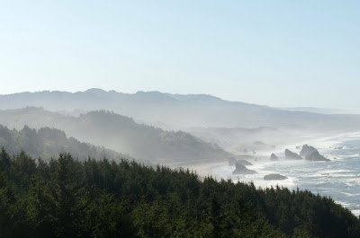
We stopped for a moment at the Cape Sebastian parking lot to check out the sweeping views in all directions.  I was clearly still fascinated by the morning light and mist.  While we're on the subject of place names, Cape Sebastian was apparently named for another long-ago exploration of this coast, this time by Sebastian Vizcaino in 1603.  Again, it's not certain if this is the cape he mentioned, because like the other explorer his latitude readings were not terribly accurate, but it was named for him in 1869 nonetheless.


In Gold Beach we drove along the north shore of the Rogue River and found this rather fascinating little city of cat condos.  Note the size of the seagull, for perspective.  Apparently, people have built these little homes for the local feral cat population.  Some have food dishes inside.  So clever!  Gold Beach, by the way, is named straightforwardly -- gold was discovered in the sands of Curry County in the early 1850s, so the name is quite appropriate.  Apparently, there were hundreds of placer miners along this beach in pioneer days.  And, although stories abound, the Rogue River was named by the original French settlers presumably because the local indians were a cantankerous bunch.  

The Rogue in this area is teeming with wildlife.  We saw a seal, cormorants and the river near the bridge was a regular traffic jam of salmon fishermen.  The season is short and they're making the most of it. I found the water dynamics here fascinating -- as you can see, the tide is fighting its way in rather forcefully in the distance, but on the shore nearer us the river flow of fresh water was working its way out.


We continued north by way of what we later discovered was the Old Coast Highway. Quite a lovely drive along the water for several miles before reconnecting with the new highway, and leading quite unexpectedly to Otter Point State Park which offers hiking trails and this lovely vista.  Our mind was on food and we were headed to Port Orford for some fish & chips at The Crazy Norwegian's, so we didn't dawdle here.  I didn't take a photo of the food, but this is the second time I've been to this place and aside from being funky and fun, that crazy Norwegian also serves what may be the best fish & chips I've found.  There's a lot to be said for that.


As we drove through Gold Beach on our return trip, I spotted this and we stopped to look.  My friend says it's one of the most photographed sights on the Oregon coast, so I don't know how I've missed it before.  She was the Mary D. Hume, built in Gold Beach in 1881 for use as a coastal freighter.  Her history is long, as she served on this coast and up into Alaska until 1978 giving her the record for length of service on this coast.  She was 97' long, served as a freighter for 10 years, then a whaler, then a tug.

Thursday, September 3, 2009

Cape Sebastian

 
Since the morning broke clear and sunny, I opted for an impromptu hike on Cape Sebastian, just south of Gold Beach. Sullivan's Oregon Coast book characterizes the hike as 'moderate' to the beach, with a 700' elevation drop. He also says it's 3.8 miles round trip but somehow forgets to mention that it's 700' back up that hill and I would not characterize that portion as moderate. It's a long, steady grind. But, this little old lady managed it at a respectable moderate pace, so it is doable.

 
Views up here are expansive, but not terribly photogenic. Ocean, ocean, and more ocean, for the most part. Winds can be strong, as evidenced by the windswept trees all around.

Much of the trail goes through lush forests as it snakes its way up and down and all around the cape.  Vistas are everywhere in all directions, assisted by frequent side trails to various viewpoints.

At the base of the cape are plenty of rocks of a very treacherous nature.  I used the zoom for this one, to try for more interest. 

 
This is about as far as I went, and you can see that I had a bit further to go to reach the beach. My camera lens had a hissy fit at this point and refused to function, stuck at optimal zoom. I was not amused, and since I felt rather naked without a usable camera, I retraced my steps. As I climbed steadily back up the hill, the fog drifted steadily into the shore, following my path and drifting into the fingers of land. We both reached the top about the same time.  Interestingly, when I reached my car and could see both north and south, I found that only the north side was fogged in. The south side was as clear as ever.

All in all, a worthy trip with some lovely views.