Friday, December 25, 2009

Tolowa Dunes State Park


Christmas Day -- another warm, clear, beautiful sunny day on the Wild Rivers Coast.  I had to get out in it and walk and wanted to go someplace I hadn't been before, so I returned to the huge Tolowa Dunes State Park just north of Crescent City, down in California.  This time, I drove to the end of Kellogg Road, where the road stops at the ocean and there's good parking and where it's possible to drive onto the beach, if you wish.  I didn't.  One could walk for long distances on the beach in either direction, but I opted for the trail that wanders up and over dunes and through grasses, paralleling the ocean.


The views were lovely from this vantage point, and I enjoyed the peace, quiet and solitude of the trail as opposed to the people and dogs and cars on parts of the beach.


Of course, I couldn't resist eventually scrambling down the dunes and walking along the shore.  This wave sneaked up on me and almost got my feet wet -- but I scrambled backwards, if inelegantly so, the foam chasing my toes with every  hop.


The incoming tide brought some nice breakers and waves.  I used the zoom for this shot, to actually see what was happening beyond my feet.


When I finally felt like turning around and heading back to the car, a big finger of fog was creeping inland around Crescent City, in the distance.  Again using the zoom, it looks as if these folks are right in the middle of the fog, but in reality they were in the same warm sunshine that bathed me so splendidly.  The camera tends to capture such scenes as this in black in white for some reason -- does not appreciate my tendency to shoot right into the sun. 

What a beautiful day!  I feel sorry for the people back east struggling with blizzards, and even for my friend in Eugene who has an icy fog to deal with today, but I'm really happy to be in this place right now!

Thursday, December 24, 2009

Adieu, Adieu


Today I went for what is probably my last walk to Harris Beach.  My last because, if all continues to go well, 3 weeks from tomorrow I will drive away from the Pacific Coast to a new home in Georgia, far from these beautiful beaches and redwood forests.  And since it is, after all, winter -- days like this are not the norm.


I hadn't planned to walk -- but the weather is so beautifully warm and sunny that it seemed a waste to stay inside.  I need the exercise, too.  From my house it's about a mile to this spot, almost all of the walk within view of the coast and one spectacular scene after another. It generally shocks outsiders to find that we can have days like this, this time of year, at such a northern latitude -- sunny, 60 degrees, balmy, beautiful.  Shhhhh -- it's a secret!


I wasn't the only one enjoying this day at the beach.  The seagulls seemed to be having a bit of a hey day, and there were other humans and dogs as well.  Up at the parking lot some folks with binoculars were looking for -- and finding -- whales.


I love this beach.  It's always beautiful, regardless of weather.  When the tide is low, which is really isn't here, it's a great place for tidepooling.


No critters here -- they're a bit further out. Still, I love the clear pools sparkling in the sun.


A beautiful day at a beautiful place.  Adieu, and thanks for many an hour of soul-soothing over the past months.

Saturday, December 5, 2009

Boy Scout Tree Trail

With perseverance comes success, they say!  I called in advance to be sure the road was open (since a fallen tree had it closed when I made the attempt a few days ago), then drove south once more yesterday to hike this trail, which is well worth the extra effort.  It's interesting that the sign doesn't say how far it is to the Boy Scout Tree, and that there's NO sign directing one to the tree from the trail.  It's almost as if they don't want you to find it.  I first hiked this trail in August, 1996 and didn't go all the way to the falls then, nor did I do so yesterday.  There are some discrepancies in directions -- William Sullivan's book says the trail rises 500' over 2.4 miles to the Boy Scout Tree, and the falls is another mile beyond.  That can't be right, if the total trail is only 2.8 miles.  I'm no great mathematician, but I can get that far.


The trail is accessed off Howland Hill Road, which cuts deep into the heart of the Jedidiah Smith Redwoods and is by itself a lovely drive through quiet forests of big trees.  Running from Crescent City to the Smith River off Hwy 199, the road is unpaved, a bit rough, and quite narrow.  Pullouts allow cars to pass when they meet.  This road also accesses the Stout Grove, which was the first grove to be dedicated back in 1929, and I saw numerous other side trails all along its length.  I opted to travel east to west, because I wanted to enjoy the forest, see it all.  If one is in a hurry, this trail is much closer to Crescent City on the western end.

 One big tree after another!


Unlike other trails I've hiked lately, this one is so deep in the forest that unless other hikers are around, there are no sounds not produced by nature.  Quiet, peaceful, utterly beautiful.  It's also a bit rough in places -- lots of big roots to cross, very narrow in places, lots of ups and downs. Everything was also quite wet, and therefore slippery, even though it hasn't rained lately.  I don't think these trails ever dry out completely, and that moisture is what makes these big babies happy. I wore my leather hiking boots for the first time in years, and I'm so glad I did -- would not have liked to try that trail in sneakers although some young folks passed me at some point literally running on the trail, so it's probably an age thing.

I don't have a lot of photos from this day -- issues between the new camera and its operator, who resists having to learn digital photography beyond point-and-shoot.  The day was beautiful -- morning mists cleared about the time I arrived and the sun speared through the trees.  I've been so spoiled by our summer-like weather that I was surprised that the air was chilled back in these deep forests.  It is, after all, December!


I can't tell you the distance to the big tree, but it's a good hike.  All in all, with maybe a 15 minute stop at the tree for lunch and photos, I was on the trail for about three and a half hours.  Finding the tree isn't all that easy, as I suggested above.  Perhaps there is normally a sign off the main trail, but there wasn't one today.  I was a little confused when I reached a trail angling uphill and to the right, wondering which way I was supposed to go, then memory from the first trip began filtering in.  I knew the tree was a bit off the trail and to the right, but I didn't remember it was that far off the trail.  If you try to find it, this is the only trail that angles off to the right, and it circles the tree.


According to Sullivan's book this tree is 20 feet thick, and I believe that is possible.  Sorry I couldn't manage to include anything in the photo for scale and it's also not a great photo but it helps illustrate the tree.  I used the self timer and took a self-portrait, arms spread and still looking miniscule,  but ego prevents me from using it.  This is a lovely and peaceful spot, with lots of room for sitting and looking at this wondrous tree, having lunch, or merely taking a rest.


I love that thick, shaggy bark with the moss on the north side.  Still hard to see any scale, but those ferns are rather large, like the ones in other photos. 
From the bottom looking up and it's still impossible to capture a real sense of its size as it reaches for the sky.

Tuesday, December 1, 2009

Tolowa Dunes State Park


Egret, off to the side of Alder Marsh Trail

I left home this morning with the intention of hiking in the redwoods, on the Boy Scout Tree Trail in Jedediah Smith Redwoods State Park.  I hiked this trail over 13 years ago, and remember that it was a nice walk.  Unfortunately, Mother Nature had other ideas for me today: a tree fell over the gravel access road yesterday and the road was closed from both ends.  So much for that idea!

Since it was a beautiful day and I was almost in Crescent City, I drove into town and stopped at the Parks Information office -- and ended up going for a nice walk in Tolowa Dunes State Park.  This lightly-developed park covers about 5000 acres of prime Pacific Ocean shoreline and houses "some of the finest wetlands habitat on the California coast" according to the brochure.  The area is an ancient sand dune complex that has evolved into many different ecological communities including ocean beach, river, open and vegetated sand dunes, wooded ridges and wetlands, according to the brochure.  It's an important birding habitat, and while I heard a wide variety of birdsong everywhere I went, I didn't see very many. The fellow above was roosting in a tree along a side trail.  That's almost full zoom on my 24x zoom lens, so forgive the hand-held lack of total focus. I find it really hard to hold it perfectly still at that focal length.


A small, unnamed marsh/lake on the west side of the loop trail.  Very peaceful.

I only touched a small fraction of the park.  A woman in the visitor's center directed me to the Lake Earl Wildlife Area, at the southern tip.  From here, I took the Cadre Point Loop Trail through meadows and wetlands and forests, although I never actually saw Lake Earl.  The loop trail follows the edge of it for some distance, but too far inland to actually see any of the lake.    I'd like to return someday, try a different section.  The loop trail is well-marked, but most side trails are not.  Most simply have a sign that says 'trail'.  I did take one trail that was marked "Alder Marsh Trail, 0.4 Miles'.  I'd been hiking for a couple of hours at this point, and was hoping for a log or rock to sit in the sunshine and have a snack -- but there's literally nothing out there but marsh grasses and plants and birds.  Very nice side trail, however.


Alder Marsh


The trail followed open meadows....


Wooded lanes....

and the occasional wetland area....


Although there were no signs, I'm fairly certain this is Lake Tolowa.  I'm guessing there's far more water here during other seasons.  In the distance are the dunes and the ocean.

Those of you in colder climes can eat your heart out -- you can see the sunshine, and I was hiking in lightweight cotton capris and t-shirt.  On the first of December.  And I'm not one with a lot of cold tolerance.   When I returned to my car around noon, after walking for about 2.5  hours, the temp was 58 -- and it felt much warmer because of all that sunshine and lack of wind. It's days like this when I know why I moved to this area!

Sunday, November 29, 2009

Sisters Rocks State Park -- and a Nice Sunset


One of Oregon's newest state parks lies about halfway between Gold Beach and Port Orford, off Highway 101.  Totally undeveloped, even unmarked, the views are well worth the effort required to find the spot!  Even on this day when the sky was blue and the air warm, the mists kept a veil over most of the coast.  That distant headland is Cape Sebastian.

The quest was for a secret sea cave, which William Sullivan wrote about in an article in the Eugene Register-Guard On June 29.  We never found that, but the spot was spectacular and we really didn't mind, although the mist did adversely affect the clarity of the photography.  Frankly, to me it was one of those places that is so spectacular you really can't capture it with a camera, anyway.  But I tried. Somehow, probably because I was so captured by this one vista, I didn't get any photos of the three large sea stacks that lie at the end of the road, and where the sea cave is supposed to be.


There is no sign on the highway, other than a standard Oregon State Parks sign with no name.  About 13 miles south of Port Orford, and about 14 miles north of Gold Beach, between mileposts 314 and 315, an old rocky side road turns to the west beside a bluff.  Sullivan advises parking your car immediately, and I have to agree, but we were in a pickup with high ground clearance so we followed the rutted road a short distance to a locked metal gate.  Trust me, there is absolutely nothing on the highway that indicates any reason to pull off the highway here.  We had serious doubts we were in the right place, but it was the only possibility between those mileposts so we gave it a try. A short walk down the road leads to the above vistas plus more to the north all the way to Humbug Mountain and three giant sea stacks from which the park takes its name. 


Earlier, we'd scouted a location for some sunset photography and arrived at Pistol River State Park just in time to watch the day come to a glorious close.

Saturday, November 28, 2009

Crissey Field State Park


You'd never know it's almost December.  Warm sunshine and clear blue skies (despite the photo above!). I'm not sure why the camera faded this out -- we are still adjusting to one another and there was a bit of glare for it to deal with.  I've been to Crissey Field often and generally it's a quiet beach for solitary strolling.  Not today!  I've never seen so many visitors -- with and without dogs.  All drawn to the same sunshine that pulled me from the house, no doubt. As you can see, the waves were big and coming in one on top of another.  Mesmerizing to watch.


When I first arrived, a couple of surf fishermen were trying their luck but, unfortunately, weren't having any.  At this point the wind had a real bite to it and I pulled out my rain jacket to use as a windbreaker. So glad I had it with me -- I was chilly in my cotton sweats.  I walked all the way to the first point in the distance and would have gone further, but the tide was too high and I didn't want to scramble over rocks.  It's a good distance, as it is.  A fine walk for a Saturday morning!


This is what greeted me as I emerged from the path that led from the visitor's center (oddly this center is closed on weekends -- surprising because it's not only a state park, it's also a "welcome to Oregon" visitors center).  It sits barely over the stateline from California. 


Clearly, I was fascinated by the waves breaking in tiers all along the beach.  Capturing this with a camera is not all that easy -- you really can't sense the size of these boys but it's fun trying.  The sand along this beach is quite different from those nearer Brookings and further up the coast.  It's blacker and grittier and more filled with driftwood and rocks near the water.

Friday, November 27, 2009

Indian Sands -- and A Few Other Spots

Surf crashing off the Indian Sands area

I took advantage of an unexpected bit of sunshine this morning and headed out on a short hike in an effort to see some places I hadn't seen, and to play with my new camera.  My first stop was at the Indian Sands viewpoint, which is just south of the Thomas Creek Bridge viewpoint. The above photo was taken using the camera's extreme (24x) zoom, and I'm pleased with the results.  Not great focus on the exploding waves, but I suspect I could have controlled that by using manual adjustments rather than leaving it on automatic.

Off into the forest I went, to see what I could see.  I found the trails here to be really confusing.  Shortly after starting down the trail there is a fork -- a nice looking trail angles off to the left, and what appears to be the main trail continues straight ahead.  I opted to stay with the 'main' trail, but almost immediately the trail forked once more.  No signs of any kind.  For no particular reason, I opted for the trail to the right, as they both went downhill and I assumed they'd either meet up again shortly, or at least both take me to the same place.  In the end, that's what happened.

The trail I took is nicely cut with switchbacks that take some of the sting out of the fairly steep descent.  Lots of offshoot trails branch off this one, but I found it easy to follow what I assumed was the primary trail. Both this and the other trail did end up at the same spot, where a warning sign tells of dangers ahead in the sands and cliffs.  Some amount of scrambling is needed from this point to reach the Oregon Coast Trail, but there are several choices with greater and lesser degrees of difficulty.  When I returned, I decided to take the other trail, to be sure it ended up at the same place and to see what I missed.  This trail is steep and straight, not one switchback, and is fairly slippery with packed clay, particularly on a day after a hard rain.  There was enough forest duff along the sides of the trail to stay with and avoid slipping, but given a choice, I'd opt for the other, longer, trail with switchbacks.


Lots of mushrooms out in the forest today, including a few of these, which have always fascinated me.  You see them in forests everywhere, but you don't really want to mess with them.  They are mildly poisonous, also hallucinogenic.  It's the amanita muscaria -- not to be confused with its cousin, the amanita verna, or destroying angel, which is deadly.


Indian Sands is a large area of craggy dunes that are not particularly soft.  Much of that sandy-looking stuff is actually a hard, somewhat slippery, substance that's probably a result of continuous exposure to high winds.  Much of it is also sand.  I would have explored more today, but the winds were really strong and a bit obnoxious, so I opted to cut my visit short.  This is my second outing to this particular point, although from a different trailhead.  I'd hoped to continue on across that ridge, but -- it just wasn't fun.


Back in the car, I headed south towards Brookings but stopped at the House Rock viewpoint.  Again, the winds were strong and annoying, so I only stayed for a moment.  Lovely views, however, and plenty of hiking opportunities.


Interesting how the camera captured this image of Whaleshead Island in black and white.  I took this photo from another stop, a wide pullout just before reaching Brookings.  I loved the way the waves looked in the glare, and wondered how the new camera would handle such conditions. 

Wednesday, November 25, 2009

Tonight's Sunset


I just captured this from the Port of Brookings Webcam (link off to the right), and couldn't resist putting it up here.  I think it's about the prettiest scene I've ever seen this webcam capture. 

Have you missed me?  I've been out of commission for awhile, with my camera in the shop for repair and on seemingly endless 'parts hold'.  Nikon, bless them, decided yesterday to replace it and promptly shipped it overnight and I am now back in business and awaiting another lovely day for photography.  I walked in the redwoods this morning, saw a huge herd of Roosevelt Elk along the highway with the ocean and surf in the background.  Could have killed for my camera, but alas, it had not yet arrived.  Kudos to Nikon, by the way.  They not only replaced the camera with a brand new one, they also gave me a significantly upgraded camera rather than a direct replacement.  Could be they just didn't have any of the other kind left in stock, but I'm sure they could have found something in the same price range to send.  I took the new baby out for a test run and am very pleased with it.  Not quite a DSLR, but nice.

Friday, October 30, 2009

Umpqua River Road and Oregon Dunes


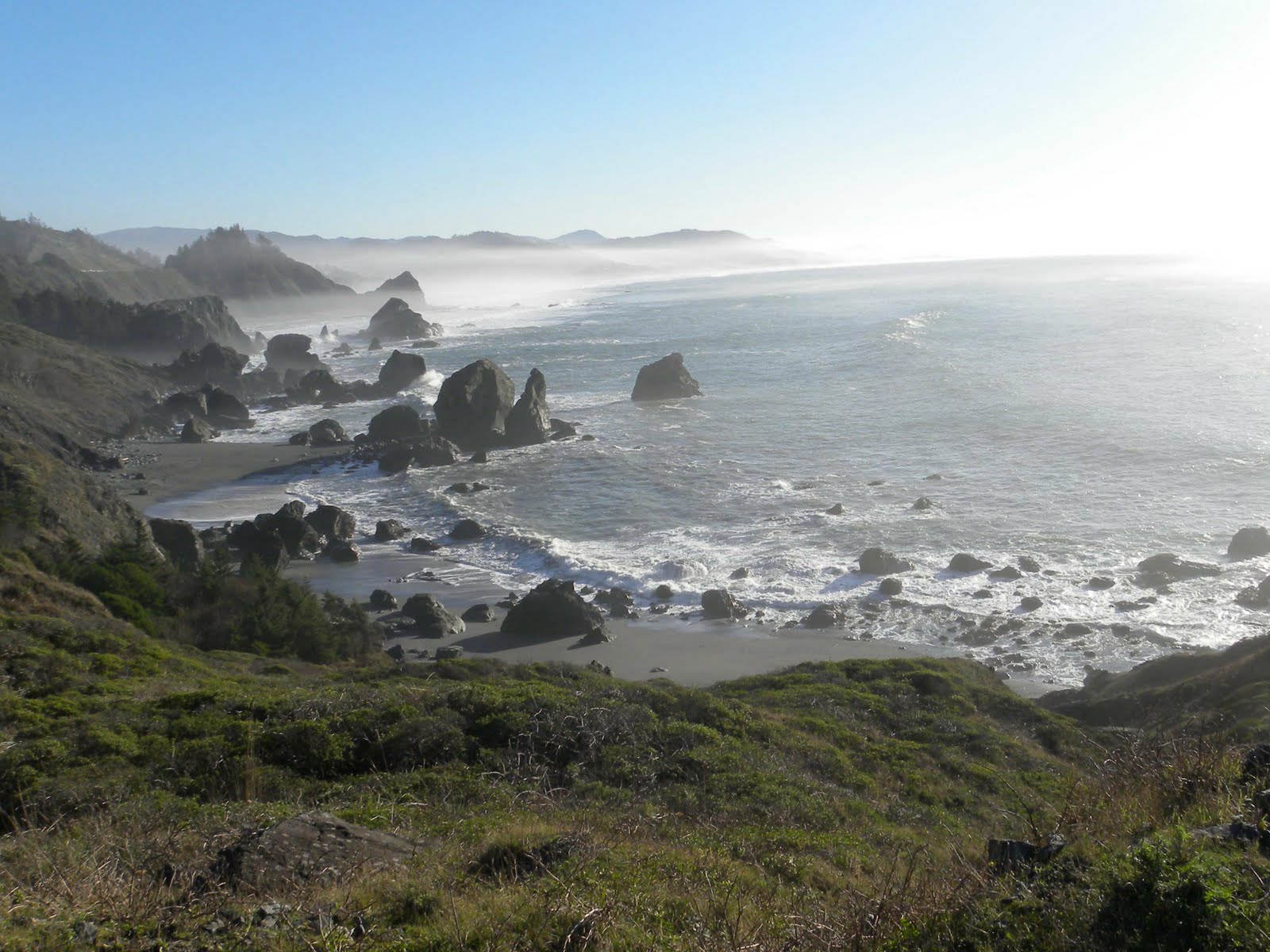
I needed to go to Eugene earlier this week so I took advantage of that and tried a new highway and dawdled hither and yon to see things I had either never seen, or hadn't seen for a long time.  Driving up the coast to Florence I was treated to some big waves rolling in, all along the road.  Just beautiful, and yet I found them a bit difficult to capture with the camera.  These are probably about 20 feet high. My camera (which is now in the hands of Nikon once more) put nasty little black zones on the upper corners and I had a tough time cropping the photos to eliminate those corners while maintaining the photo. So -- that's my excuse.  This photo was taken somewhere between Gold Beach and Port Orford, and that's about all I can tell you about that.


I didn't take many photos on the trip north -- lots of showers plus I had appointments and errands to run in town.  I returned by way of Highway 38, which runs from just south of Roseburg to Reedsport.  Although I'd heard that this was a fast alternate route, I never really realized that it was also an extremely beautiful drive.  I found very few places to stop and photograph the river, but it was present for most of the trip. As you can see, the fall colors are just past their prime -- many leaves have fallen -- but still evident.  The above photo was taken just east of the small hamlet of Scottsburg, which lies about 16 miles inland.


Looks more like a lake than a river, doesn't it?  Just west of  Scottsburg I found a lovely little park with a boat dock that extended out into the water.  As so often happens, the photo of one portion of the scene cannot adequately capture the sense of being surrounded by this in all directions.


About three miles east of Reedsport I passed the Dean Creek elk viewing area, which was rather impressive.  This photo was taken from a lovely interpretive center, but this meadow stretches for I'd guess close to two miles.  The elk herd, which numbers about 100, were lazily grazing and resting further east in an area with no place to stop and photograph them.


The Oregon Dunes National Recreation Area extends roughly from Coos Bay north to Florence and is quite spectacular with many opportunities along the way to stop and enjoy the big dunes. I've passed them often, but hadn't been on them for years. I intended to change that this trip.  My first stop was the Umpqua Lighthouse, which sits above the water and dunes in a really lovely state park.  That big Fresnel lens was hard at work but naturally, it doesn't show here.  I drove on down the road, exploring, to see what I could see and try to get closer to the water.  I followed my nose to a parking lot on the coast near the two large stone jetties that go out into the ocean.  Sullivan's book says that the area between them is a commercial oyster and mussel farm.


This shows how far inland the lighthouse sits from the beach.


This is the south jetty.  The other is angled on the right horizon and the seafood farm lies between.  I didn't go much further than this, since I had been a little dizzy all day and this required better balance than I could summon. Those rocks make for hard, sharp landings and are perfect breeding grounds for broken ankles.


The place I most wanted to stop was here, where the largest dunes are and where the dreaded dune buggies are banned.  From here, one can walk the dunes out to the beach for a 4.8 mile round trip hike over loose, shifting sand.  I've never done that, and didn't even come close today.  I first found this place thirteen years ago during my first summer in Oregon.  A friend from Georgia was visiting and we were staying in the adjacent Eel Creek Campground.  Both of us were more than a little surprised at what we found when we went exploring, and I wish I could find the photos I took that late afternoon when the shadows delineated the swooping lines of the dunes and the sky was bright blue.  This used to be known as the Umpqua Dunes, but as you can see the name has been changed to the John Dellenback Dunes and that is what the highway sign will read if you search this out.


The access trail from the parking lot is about a half mile and crosses through these ancient dunes that are overgrown with woods filled with Douglas fir, huckleberry and huge rhododendrons, among others.


When you emerge from the woods and access trail you are confronted with this huge dune.  Not a lovely photo, but the man walking on top does give some indication of size.  Once you reach the top of this dune it's possible to walk the crest of several similar and connected dunes for some distance.  I didn't go terribly far because I was a little under the weather.  The light wasn't great for photography anyway, but it's a place well worth visiting.  When I was there with my friend, we played in the sand like a couple of kids, scrambling up and down the dunes.


From the top of the big dunes the vista is sweeping in all directions.  I'd love to walk all the way to the beach and camp overnight but....somehow that seems unlikely to happen.  Alas.  Beautiful to see regardless.

I'd been looking forward to fish & chips at The Crazy Norwegian in Port Orford -- my mouth had been watering for days -- but when I arrived right at dinner time I found them closed. Seems that this time of year they are only open Thursday through Sunday.  What a disappointment!